
Border history
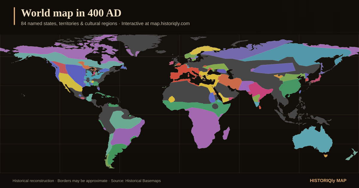
The interactive map lets you inspect named territories in 400 AD and compare them to earlier or later snapshots on the timeline.
Classical historical map
Explore a reconstruction of the world around 400 AD. Follow Mediterranean, Persian, Indian, and East Asian powers as the classical world expands and collides.
Snapshot at a glance
Counts come directly from this snapshot and the historical layers available in HistorIQly Map.
These names are encoded in the boundary dataset. Inclusion does not settle disputed borders, sovereignty, spelling, or historical interpretation.
What this snapshot shows
The interactive map lets you inspect named territories in 400 AD and compare them to earlier or later snapshots on the timeline.
Conflicts connected to 400 AD
These editorial date ranges include 400 AD. Some records group intermittent campaigns or long-running conflict series, so inclusion does not mean continuous fighting in that exact year.
376 AD – 476 AD
Western Roman Empire vs Various Germanic tribes vs Huns
A century of invasions, civil wars, and collapse — from the Gothic crossing of the Danube to the deposition of the last Western emperor in 476 AD.
Key battles and events: Adrianople (378); Sack of Rome (410)
370 AD – 454 AD
Hunnic Empire (Attila) vs Roman Empire & Germanic kingdoms
The Huns burst out of the Central Asian steppes, triggering the great migrations that would destroy the Western Roman Empire. Under Attila, the 'Scourge of God', the Hunnic Empire terrorised both halves of the Roman world before collapsing after his death.
Key battles and events: Battle of the Catalaunian Plains (451); Invasion of Italy (452)
304 AD – 439 AD
Various Chinese and nomadic states (Former Zhao, Later Zhao, Former Qin, etc.)
After the fall of the Western Jin Dynasty, northern China fractured into a chaotic succession of short-lived kingdoms founded by both Chinese and nomadic rulers. Over a century of devastating warfare depopulated the north and drove mass migration southward.
Key battles and events: Battle of Fei River (383 AD); Sack of Luoyang (311 AD)
270 AD – 525 AD
Kingdom of Aksum vs Kingdom of Himyar
The powerful East African kingdom of Aksum fought the Himyarite kingdom across the Red Sea for control of trade routes. The wars culminated in Aksum's 525 AD invasion of Himyar after the Jewish Himyarite king Dhu Nuwas persecuted Christians.
Key battles and events: Aksumite invasion of Yemen (c. 270 AD); Final invasion under Kaleb (525 AD)
200 BC – 500 AD
Monte Albán (Zapotec state) vs Cuicatlán Cañada polities vs Mixtec highland groups vs Valley of Oaxaca rivals
From its hilltop capital above the Valley of Oaxaca, the Zapotec state at Monte Albán expanded by military conquest, commemorating subjugated places on the Building J 'conquest slabs' and extending control into the Cuicatlán Cañada.
Key battles and events: Conquest of the Cuicatlán Cañada (c. 200 BCE); Construction of Building J conquest slabs (c. 100 BCE)
400 BC – 900 AD
Tikal vs Calakmul vs Caracol vs Dos Pilas vs Palenque vs Copán vs other Maya polities
Over a millennium of warfare among rival Classic Maya polities, dominated by the Tikal–Calakmul superpower rivalry and a web of proxy conflicts that shaped Classic Maya civilization.
Key battles and events: Caracol sack of Tikal (562 CE); Dos Pilas campaigns against Tikal (648–761 CE)
Landmarks standing in 400 AD
Sites already standing (or still being used) in 400 AD, drawn from the map's landmark layers.
Built 400 AD · Asia
Cluster of Hindu temple ruins built by the Champa Kingdom in a jungle valley in central Vietnam
Built 400 AD · Asia
The holiest Shiva temple in Nepal, a UNESCO World Heritage Site on the banks of the Bagmati River with sacred cremation ghats
Built 366 AD · Asia
UNESCO complex of 492 Buddhist cave temples near Dunhuang containing a thousand years of murals and sculptures along the ancient Silk Road
Built 335 AD · Asia
Church built at the site of Christ's crucifixion and resurrection
Built 330 AD · Europe
Gateway between Europe and Asia, hub of East-West trade
Built 326 AD · Asia
One of the oldest continuously operating churches, built over the traditional birthplace of Jesus in Bethlehem by Emperor Constantine
Boundary source and context layers
Boundary geometry is adapted from Historical Basemaps, a GPL-3.0 project built for world- and continent-scale historical mapping. The source is a work in progress: pre-modern territories can overlap, borders are often disputed, and a snapshot should be read as a reconstruction around 400 AD, not as survey-level fact.
The source marks 367 of 367 geometries in this snapshot as approximate.
Conflicts, landmarks, trade routes, and biographies come from separate HistorIQly editorial datasets. They provide discovery context but do not yet expose a citation for every individual record; verify a specific claim with specialist sources before citing it.
Frequently asked questions
The 400 AD source snapshot reconstructs political borders, territories, and named states for around 400 AD. You can inspect individual territories, view linked historical figures, and compare this snapshot with nearby years like 200 AD and 300 AD.
HistorIQly records whose date ranges include 400 AD include Fall of the Western Roman Empire, Hunnic Invasions of Europe, Wars of the Sixteen Kingdoms, Aksumite–Himyarite Wars, Monte Albán Zapotec Conquest State. Long-running entries may represent intermittent campaigns rather than continuous warfare.
HistorIQly features 144 historical figures across all eras. Browse the interactive map to discover people connected to the classical period.
HistorIQly Map includes 49 historical snapshots spanning from 3000 BC through the modern era, covering the classical era and every other major period of world history.
Example labels encoded in the 400 AD source snapshot include Western Roman Empire, Persia, Gupta Empire, Eastern Roman Empire, Sixteen Kingdoms, Hunnic Empire. These labels and reconstructed boundaries can be approximate or disputed; inspect the map methodology before using them for research.
Nearby years
Related map topics
Historical maps by year
Choose from 49 historical world maps by year. Explore borders, empires, wars, landmarks, trade routes, and people from 3000 BC to the modern era.
Ancient history map
Explore ancient world maps from 3000 BC through the classical era. Follow early civilizations, empires, trade routes, landmarks, and borders.
World history atlas
Browse an interactive world history atlas with maps of empires, wars, trade routes, landmarks, and influential figures from ancient history through the modern era.